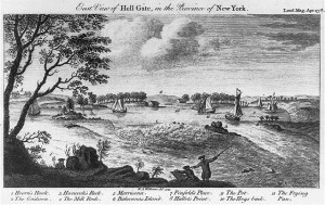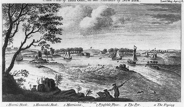
In digging around a little further for information on Hoorn’s Hook and Hell’s Gate — two East River spots mentioned in the Gracie Mansion podcast — I came across the incredible illustration among the Library of Congress’s digital images page.
Labeled the ‘East View of Hell’s Gate, in the Province of New York’, the piece ran in The London Magazine in April 1778. The London was a anti-Tory publication that naturally took great interest in the war across the pond.
That April, the magazine ran a ‘Description of New York Island’ paying special attention to places of ‘dangerous passage’, including, naturally, the East River’s most treacherous pass, ‘that remarkable spot, called Hell’s Gate’.
(By the way, you can read the whole issue here, thanks to the Hathi Trust. The magazine features such articles as ‘The Hypochondriack’, ‘The False Prude’ and ‘A Turkish Sentimental Tale’ and columns on poetry and mathematics. But the article on New York is not, curiously, available to read.)
Alongside this article ran the plate above; however, time and distorted perspective have almost entirely obscured the precise location where the picture was etched. Our only clues are a set of numbered details, most of them old place names that have faded into obscurity.
1 Hoorn’s Hook (mentioned in the podcast)
2 The Gridiron
3 Hancock’s Rock
4 The Mill Rock (Clue: This is still around.)
5 Morrisana (Probably not the closely named neighborhood but the home of this person.)
6 Bahannas Island
7 Pinfold’s Place
8 Hallet’s Point (Clue: Part of this today.)
9 The Pot
10 The Hog’s Back
11 The Frying Pan
How many of them could you place approximately on a current map today? (Click on the illustration for a bigger view) I admit, many of them have me stumped. Take a guess, then look at a Google Map overhead look of the area for comparison. This article reveals the identity of a few of these.


2 replies on “Puzzle time! Can you identify these details of Hell’s Gate?”
Hi Bower Boys,This is really good share here. I am wondering if you got the answer for this one? I searched your blog and no luck at all. Please comment here if you have thanks.
My opinion is (taking into account that the perspective is a little off) 1. is where Gracie’s Mansion now stands. 2&3 are combined to make Roosevelt Island (before possible extension via landfill). 4 is now Mill Island which was made by filling in with landfill the two smaller Mill Rock Islands. 5 is now Mott Haven and the image shows the Southern shoreline view. Jordan Lawrence Mott bought the Morrisena Estate from Lew Morris’s grandchildren. 6 is most likely Wards Island before it was landfilled into Randall’s Island. 7 is now Astoria, NY. 8 still exists as Hallett’s Point. 9 & 11 were historically designated as rough water (rapids) before the clearing by explosives of the rocks of the East River (around 1850). The exploded rocks were what was used to landfill the two small Mill Rock Islands into one island (and possibly some of Roosevelt Island). It may also be related to the creation of the term of going from the Pot to the Frying Pan (as both were risky endeavors via ship), and 10 is the currently still called the very southern tip of Randall’s Island, again, which was landfilled in to create on big island with Ward’s Island.